Venue
| Ghent Gent |
|||
|---|---|---|---|
| Municipality | |||

|
|||
|
|||

Ghent
Location in Belgium
Ghent in the province of East Flanders
 |
|||
| Coordinates: 51°3'N 3°44'E? / ?51.050°N 3.733°ECoordinates: 51°3'N 3°44'E? / ?51.050°N 3.733°E | |||
| Country | Belgium | ||
| Community | Flemish Community | ||
| Region | Flemish Region | ||
| Province | East Flanders | ||
| Arrondissement | Ghent | ||
| Area | |||
| • Total | 156.18 km2 (60.30 sq mi) | ||
| Population (1 January 2017)[1] | |||
| • Total | 259,083 | ||
| • Density | 1,700/km2 (4,300/sq mi) | ||
| Postal codes | 9000–9052 | ||
| Area codes | 09 | ||
| Website | www.gent.be | ||

Ghent (/g?nt/; Dutch: Gent pronounced [??nt] (![]() listen); French: Gand pronounced [g?~] (
listen); French: Gand pronounced [g?~] (![]() listen); German: Gent pronounced ['g?nt] (
listen); German: Gent pronounced ['g?nt] (![]() listen)) is a city and a municipality in the Flemish Region of Belgium. It is the capital and largest city of the East Flanders province and after Antwerp the largest municipality of Belgium. The city started as a settlement at the confluence of the Rivers Scheldt and Leie and in the Late Middle Ages became one of the largest and richest cities of northern Europe, with some 50,000 people in 1300. It is a port and university city.
listen)) is a city and a municipality in the Flemish Region of Belgium. It is the capital and largest city of the East Flanders province and after Antwerp the largest municipality of Belgium. The city started as a settlement at the confluence of the Rivers Scheldt and Leie and in the Late Middle Ages became one of the largest and richest cities of northern Europe, with some 50,000 people in 1300. It is a port and university city.
The ten-day-long Ghent Festival (Gentse Feesten in Dutch) is held every year and attended by about 1–1.5 million visitors.
History[edit]

Archaeological evidence shows human presence in the region of the confluence of Scheldt and Leie going back as far as the Stone Age and the Iron Age.[5]
Most historians believe that the older name for Ghent, 'Ganda', is derived from the Celtic word ganda which means confluence.[5] Other sources connect its name with an obscure deity named Gontia.[6]
There are no written records of the Roman period, but archaeological research confirms that the region of Ghent was further inhabited.
When the Franks invaded the Roman territories from the end of the 4th century and well into the 5th century, they brought their language with them and Celtic and Latin were replaced by Old Dutch.
Middle Ages[edit]
Around 650, Saint Amand founded two abbeys in Ghent: St. Peter's (Blandinium) and Saint Bavo's Abbey. The city grew from several nuclei, the abbeys and a commercial centre. Around 800, Louis the Pious, son of Charlemagne, appointed Einhard, the biographer of Charlemagne, as abbot of both abbeys. In 851 and 879, the city was however attacked and plundered twice by the Vikings.
Within the protection of the County of Flanders, the city recovered and flourished from the 11th century, growing to become a small city-state. By the 13th century, Ghent was the biggest city in Europe north of the Alps after Paris; it was bigger than Cologne or Moscow.[7] Within the city walls lived up to 65,000 people. The belfry and the towers of the Saint Bavo Cathedral and Saint Nicholas' Church are just a few examples of the skyline of the period.
The rivers flowed in an area where much land was periodically flooded. These rich grass 'meersen' ("water-meadows": a word related to the English 'marsh') were ideally suited for herding sheep, the wool of which was used for making cloth. During the Middle Ages Ghent was the leading city for cloth.
The wool industry, originally established at Bruges, created the first European industrialized zone in Ghent in the High Middle Ages. The mercantile zone was so highly developed that wool had to be imported from Scotland and England. This was one of the reasons for Flanders' good relationship with Scotland and England. Ghent was the birthplace of John of Gaunt, Duke of Lancaster. Trade with England (but not Scotland) suffered significantly during the Hundred Years' War.
Early modern period[edit]
The city recovered in the 15th century, when Flanders was united with neighbouring provinces under the Dukes of Burgundy. High taxes led to a rebellion and eventually the Battle of Gavere in 1453, in which Ghent suffered a terrible defeat at the hands of Philip the Good. Around this time the centre of political and social importance in the Low Countries started to shift from Flanders (Bruges–Ghent) to Brabant (Antwerp–Brussels), although Ghent continued to play an important role. With Bruges, the city led two revolts against Maximilian of Austria, the first monarch of the House of Habsburg to rule Flanders.


In 1500, Juana of Castile gave birth to Charles V, who became Holy Roman Emperor and King of Spain. Although native to Ghent, he punished the city after the 1539 Revolt of Ghent and obliged the city's nobles to walk in front of the Emperor barefoot with a noose (Dutch: "strop") around the neck; since this incident, the people of Ghent have been called "Stroppendragers" (noose bearers). Saint Bavo Abbey (not to be confused with the nearby Saint Bavo Cathedral) was abolished, torn down, and replaced with a fortress for Royal Spanish troops. Only a small portion of the abbey was spared demolition.
The late 16th and the 17th centuries brought devastation because of the Eighty Years' War. The war ended the role of Ghent as a centre of international importance. In 1745, the city was captured by French forces during the War of the Austrian Succession before being returned to the Empire of Austria under the House of Habsburg following the Treaty of Aix-la-Chapelle in 1748, when this part of Flanders became known as the Austrian Netherlands until 1815, the exile of the French Emperor Napoleon I, the end of the French Revolutionary and later Napoleonic Wars and the peace treaties arrived at by the Congress of Vienna.
19th century[edit]
In the 18th and 19th centuries, the textile industry flourished again in Ghent. Lieven Bauwens, having smuggled the industrial and factory machine plans out of England, introduced the first mechanical weaving machine on the European continent in 1800.
The Treaty of Ghent, negotiated here and adopted on Christmas Eve 1814, formally ended the War of 1812 between Great Britain and the United States (the North American phase of the Napoleonic Wars). After the Battle of Waterloo, Ghent and Flanders, previously ruled from the House of Habsburg in Vienna as the Austrian Netherlands, became a part of the United Kingdom of the Netherlands with the northern Dutch for 15 years. In this period, Ghent established its own university (1816)[8] and a new connection to the sea (1824–27).
After the Belgian Revolution, with the loss of port access to the sea for more than a decade, the local economy collapsed and the first Belgian trade union originated in Ghent. In 1913 there was a world exhibition in Ghent.[8] As a preparation for these festivities, the Sint-Pieters railway station was completed in 1912.
20th century[edit]
Ghent was occupied by the Germans in both World Wars but escaped severe destruction. The life of the people and the German invaders in Ghent during World War I is described by H. Wandt in "etappenleven te Gent"[citation needed]. In World War II the city was liberated by the British 7th "Desert Rats" Armoured Division and local Belgian fighters on 6 September 1944.
Climate[edit]
The climate in this area has mild differences between highs and lows, and there is adequate rainfall year-round. According to the Köppen Climate Classification system, Ghent has a marine west coast climate, abbreviated "Cfb" on climate maps.[9]
| Climate data for Ghent, Belgium | |||||||||||||
|---|---|---|---|---|---|---|---|---|---|---|---|---|---|
| Month | Jan | Feb | Mar | Apr | May | Jun | Jul | Aug | Sep | Oct | Nov | Dec | Year |
| Average high °C (°F) | 6 (43) |
6 (42) |
10 (50) |
13 (55) |
17 (62) |
19 (67) |
22 (72) |
22 (72) |
18 (65) |
14 (58) |
9 (49) |
8 (46) |
14 (57) |
| Average low °C (°F) | 2 (36) |
1 (34) |
4 (40) |
6 (43) |
10 (50) |
13 (55) |
15 (59) |
14 (58) |
12 (54) |
9 (48) |
6 (42) |
4 (39) |
8 (46) |
| Average precipitation days | 21 | 15 | 20 | 18 | 20 | 19 | 16 | 17 | 18 | 19 | 19 | 19 | 221 |
| Source: Weatherbase [10] | |||||||||||||
Tourism[edit]

Architecture[edit]

Much of the city's medieval architecture remains intact and is remarkably well preserved and restored. Its centre is the largest carfree area in Belgium. Highlights are the Saint Bavo Cathedral with the Ghent Altarpiece, the belfry, the Gravensteen castle, and the splendid architecture along the old Graslei harbour. Ghent has established a blend between comfort of living and history; it is not a city-museum. The city of Ghent also houses three béguinages and numerous churches including Saint-Jacob's church, Saint-Nicolas' church, Saint Michael's church and St. Stefanus.
The beguinages, as well as the belfry and adjacent cloth hall, were recognized by UNESCO as World Heritage Sites in 1998 and 1999.
In the 19th century Ghent's most famous architect, Louis Roelandt, built the university hall Aula, the opera house and the main courthouse. Highlights of modern architecture are the university buildings (the Boekentoren or Book Tower) by Henry Van de Velde. There are also a few theatres from diverse periods.
The Zebrastraat, a social experiment in which an entirely renovated site unites living, economy and culture, can also be found in Ghent.
Campo Santo is a famous Catholic burial site of the nobility and artists.


Museums[edit]
Important museums in Ghent are the Museum voor Schone Kunsten (Museum of Fine Arts), with paintings by Hieronymus Bosch, Peter Paul Rubens, and many Flemish masters; the SMAK or Stedelijk Museum voor Actuele Kunst (City Museum for Contemporary Art), with works of the 20th century, including Joseph Beuys and Andy Warhol; and the Design Museum Gent with masterpieces of Victor Horta and Le Corbusier. The Huis van Alijn (House of the Alijn family) was originally a beguinage and is now a museum for folk art where theatre and puppet shows for children are presented. The Museum voor Industriële Archeologie en Textiel or MIAT displays the industrial strength of Ghent with recreations of workshops and stores from the 1800s and original spinning and weaving machines that remain from the time when the building was a weaving mill. The Ghent City Museum (Stadsmuseum, abbreviated STAM), is committed to recording and explaining the city's past and its inhabitants, and to preserving the present for future generations.
Restaurants and culinary traditions[edit]
In Ghent and other regions of East-Flanders, bakeries sell a donut-shaped bun called a "mastel" (plural "mastellen"), which is basically a bagel. "Mastellen" are also called "Saint Hubert bread", because on the Saint's feast day, which is 3 November, the bakers bring their batches to the early Mass to be blessed. Traditionally, it was thought that blessed mastellen immunized against rabies.
Other local delicacies are the praline chocolates from local producers such as Leonidas, the cuberdons or 'neuzekes' ('noses'), cone-shaped purple jelly-filled candies, 'babelutten' ('babblers'), hard butterscotch-like candy, and of course, on the more fiery side, the famous 'Tierenteyn', a hot but refined mustard that has some affinity to French 'Dijon' mustard.
Stoverij is a classic Flemish meat stew, preferably made with a generous addition of brown 'Trappist' (strong abbey beer) and served with French fries. 'Waterzooi' is a local stew originally made from freshwater fish caught in the rivers and creeks of Ghent, but nowadays often made with chicken instead of fish. It is usually served nouvelle-cuisine-style, and will be supplemented by a large pot on the side.
The city promotes a meat-free day on Thursdays called Donderdag Veggiedag[11][12] with vegetarian food being promoted in public canteens for civil servants and elected councillors, in all city funded schools, and promotion of vegetarian eating options in town (through the distribution of "veggie street maps"). This campaign is linked to the recognition of the detrimental environmental effects of meat production, which the United Nations' Food and Agriculture Organization has established to represent nearly one-fifth of global greenhouse gas emissions.
Ghent has the world's largest number of vegetarian restaurants per capita.[13]
Parts of this text were copied from 
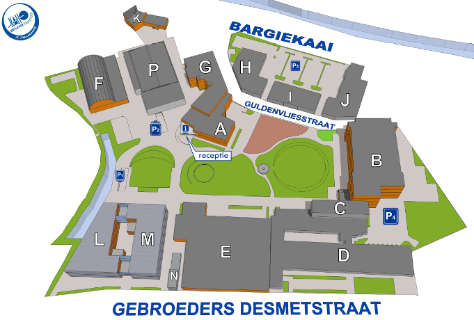
How to reach Ghent and the Conference Venue  [edit]
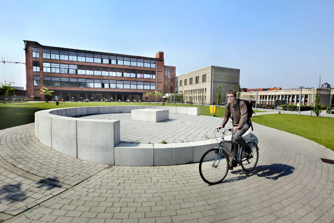
The Conference Venue
 |
|
As one of the largest cities in Belgium, Ghent has a highly developed transport system. The transport destinations you may need to use in order to reach the conference site, depending on your point of arrival and/or lodgings, are highlighted in red below.
By Plane
Ghent lies some 40 km to the west of the airport of Brussels and some 70 kms from Charleroi-(Brussels South Airport) if you fly Ryanair. See below how to get reach Ghent from these different airports.
- On arrival at Brussels Airport, probably with Brussels Airlines take a train towards Brussels, where you can change trains for Ghent at either Brussels North, Central or South (Midi). At each of these stations you can take the IC-Train either to Ostend, Knokke-Blankenberge or De Panne and exit in Ghent St.Pieters station. First stop after Brussels. (travel time approx. 35 mins)
From Brussels Airport for Gent St Pieters Station: A shuttle bus departs every 30 minutes and is €15,50 per person per trip. Taxi: It's a 55 minutes trip and will cost around €90. - From Charleroi airport you can take a bus to Charleroi Station. From there you take the train to Brussels South and change trains there for Ghent. At this station you can take the IC-Train either to Ostend, Knokke-Blankenberge or De Panne and exit in Ghent St.Pieters station. First stop after Brussels. (travel time approx 35 mins)
By Road[edit]

By car the city is accessible via two motorways:
- The E40 connects Ghent with Bruges and Ostend to the west, and with Brussels, Leuven and Liège to the east.
- The E17 connects Ghent with Sint-Niklaas and Antwerp to the north, and with Kortrijk and Lille to the south.
- De Krook is located at the end of the B401 Exit road of the E17 Motorway, city location known as Zuid
In addition Ghent also has two ringways:
- The R4 connects the outskirts of Ghent with each other and the surrounding villages, and also leads to the E40 and E17 roads.
- The R40 connects the different downtown quarters with each other and provides access to the main avenues.
Please note that de Krook is located in an area restricted to traffic and needs to be accessed via the Ring Road as the city center does not admit through traffic. Parking: Underground Public Parking is located at the end of the B401 Exit road of the E17 Motorway. This is located some 200m South East of de Krook.
By Rail[edit]

- From Germany see the German Railway Information Site and also check the information on the ICE train from Cologne to Brussels.
- From London see the EUROSTAR Information Site for information on trains between London and Brussels.
- From Paris see the THALYS Information Site for information on trains between Paris and Brussels.
- From Amsterdam see the THALYS Information Site for information on trains between Amsterdam (Shiphol Airport) and Brussels. If you take this train then you can also change trains in Antwerp and take the Ostend or Lille bound trains to reach Ghent St.Pieters station.
- More information about timetables of trains in Belgium.
The municipality of Ghent comprises five railway stations:
- Gent-Sint-Pieters Station: an international railway station with connections to Bruges, Brussels, Antwerp, Kortrijk, other Belgian towns and Lille. The station also offers a direct connection to Brussels Airport.
- Gent-Dampoort Station: an intercity railway station with connections to Sint-Niklaas, Antwerp, Kortrijk and Eeklo.
- Gentbrugge Station: a regional railway station in between the two main railway stations, Sint-Pieters and Dampoort.
- Wondelgem Station: a regional railway station with connections to Eeklo once an hour.
- Drongen Station: a regional railway station in the village of Drongen with connections to Bruges once an hour.
Public transport[edit]
Ghent has an extensive network of public transport lines, operated by De Lijn.
Trams[edit]

- Line 1: Flanders Expo – Sint-Pieters-Station – Korenmarkt (city centre) – Wondelgem - Evergem
- Line 2: Zwijnaarde Bibliotheek - Sint-Pieters-Station - Zonnestraat (city centre) - Brabantdam - Zuid - Melle Leeuw (fuse of line 21 and 22 as of May 2017[16])
- Line 4: UZ - Sint-Pieters-Station – Muide – Korenmarkt (city centre) – Zuid – Moscou
- Line 21: Zwijnaarde Bibliotheek - Sint-Pieters-Station – Zonnestraat (city centre) – Zuid – Melle Leeuw (fused into line 2)
- Line 22: Kouter - Bijlokehof - Sint-Pieters-Station – Zonnestraat (city centre) – Zuid – Gentbrugge (fused into line 2)
Buses[edit]

- Line 3: Mariakerke – Korenmarkt (city centre) – Dampoort – Gentbrugge (formerly a trolleybus line; see picture below)
- Line 5: Van Beverenplein – Sint-Jacobs (city centre) – Zuid – Heuvelpoort - Nieuw-Gent
- Line 6: Watersportbaan – Zuid – Dampoort – Meulestede - Wondelgem – Mariakerke
- Line 8: AZ Sint-Lucas - Sint-Jacobs (city centre) - Zuid - Heuvelpoort - Arteveldepark
- Line 9: Mariakerke – Malem – Sint-Pieters-Station – Ledeberg - Gentbrugge
- Line 17/18: Drongen – Malem - Korenmarkt (city centre) - Dampoort – Oostakker
- Line 38/39: Blaarmeersen – Ekkergem -Korenmarkt (city centre) – Dampoort – Sint-Amandsberg
Apart from the city buses mentioned above, Ghent also has numerous regional bus lines connecting it to towns and villages across the province of East Flanders. All of these buses stop in at least one of the city's regional bus hubs at either Sint-Pieters Station, Dampoort Station, Zuid or Rabot.
International Buses
International buses connecting Ghent to other European destinations are usually found at the Dampoort Station. A couple of private bus companies such as Eurolines and Flixbus operate from the Dampoort bus hub.
Buses to and from Belgium's second airport - Brussels South Airport Charleroi - are operated by Flibco, and can be found at the rear exit of the Sint-Pieters Station.
Useful Maps
|
|
|
|
|
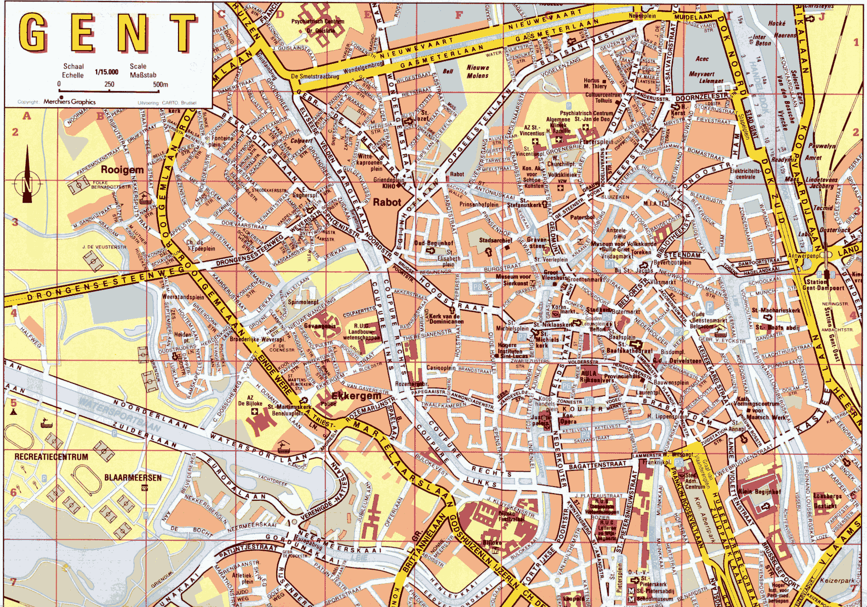
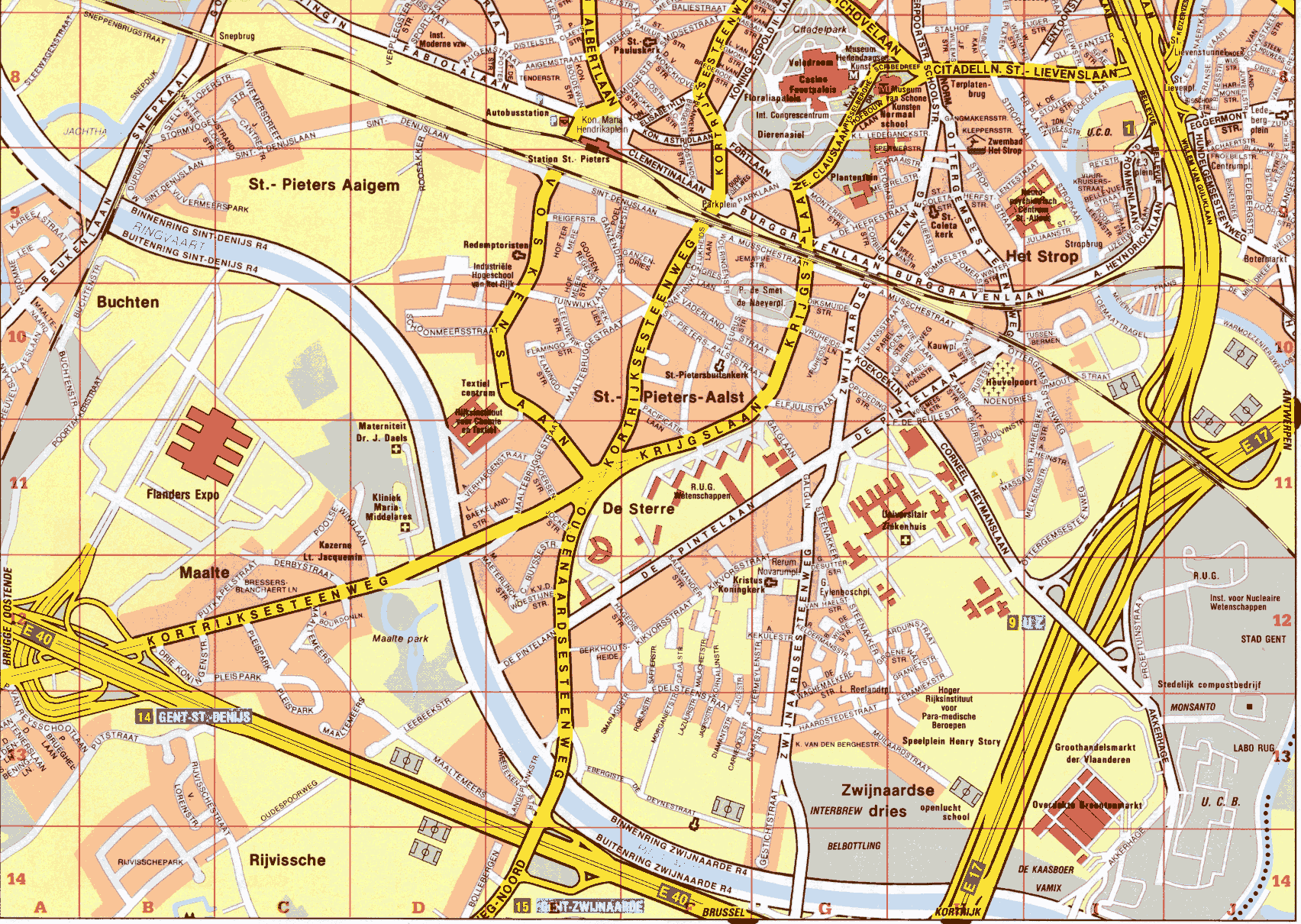
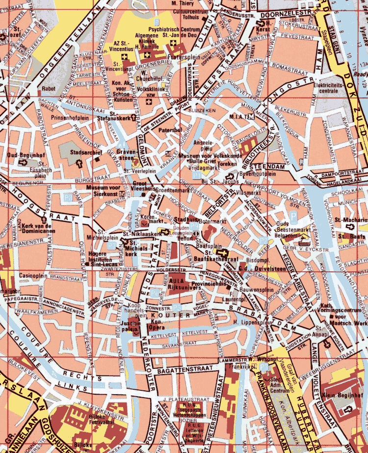
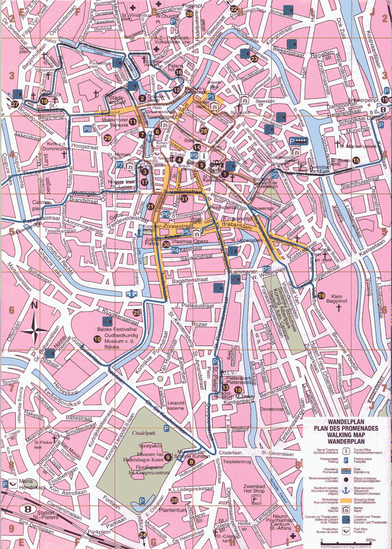
Click on the above maps to enlarge


