Venue
| City of Dundee Dùn Dè |
|||
|---|---|---|---|
| City and council area | |||

Top: Tay Rail Bridge, Middle: RRS Discovery and City Centre, Bottom left: Magdalen Yard Bandstand, Bottom right: University of Dundee.
|
|||
|
|||
| Etymology: Scottish Gaelic - Dùn Dè (Tay Fort)[1] | |||
| Nickname(s): "The City of Discovery" | |||

Dundee
Location in Scotland

Dundee
Dundee (Europe)
|
|||
| Coordinates: 56°27′43″N 2°58′15″W / 56.462°N 2.9707°WCoordinates: 56°27′43″N 2°58′15″W / 56.462°N 2.9707°W | |||
| Sovereign state | |||
| Country | |||
| Council Area | Dundee City | ||
| Lieutenancy Area | Dundee | ||
| Founded | c. 11th century AD | ||
| Burgh Charter | 1191 | ||
| City Status | 1889 | ||
| Government | |||
| • Body | Dundee City Council | ||
| • Lord Provost | [2] | ||
| • Leader of Dundee City Council | [3] | ||
| • MSPs |
|
||
| • MPs |
|
||
| Area[4] | |||
| • Total | 60 km2 (20 sq mi) | ||
| Elevation[4] | 18 m (59 ft) | ||
| Population (2016)[6] | |||
| • Total | 148,270 | ||
| • Rank | 4th, Scotland | ||
| • Density | 2,478/km2 (6,420/sq mi) | ||
| • Metro | 237,000[5] | ||
| • Language(s) | English, Scots | ||
| Demonym(s) | Dundonian | ||
| Time zone | GMT (UTC±0) | ||
| • Summer (DST) | BST (UTC+1) | ||
| Postcode Areas | DD1-5 | ||
| Area code(s) | 01382 | ||
| ISO 3166-2 | GB-DND | ||
| ONS Code | S12000042 | ||
| OS Grid Reference | NO4030 | ||
| NUTS 3 | UKM21 | ||
| Primary Airport | Dundee Airport | ||
| Website | www |
||


Dundee (/dʌnˈdiː/ (![]() listen); Scottish Gaelic: Dùn Dè [ˈt̪uːn tʲeː]) is Scotland's fourth-largest city and the 51st-most-populous built-up area in the United Kingdom. The mid-year population estimate for 2016 was 148,270, giving Dundee a population density of 2,478/km2 or 6,420/sq mi, the second-highest in Scotland. It lies within the eastern central Lowlands on the north bank of the Firth of Tay, which feeds into the North Sea. Under the name of Dundee City (officially the City of Dundee), it forms one of the 32 council areas used for local government in Scotland.
listen); Scottish Gaelic: Dùn Dè [ˈt̪uːn tʲeː]) is Scotland's fourth-largest city and the 51st-most-populous built-up area in the United Kingdom. The mid-year population estimate for 2016 was 148,270, giving Dundee a population density of 2,478/km2 or 6,420/sq mi, the second-highest in Scotland. It lies within the eastern central Lowlands on the north bank of the Firth of Tay, which feeds into the North Sea. Under the name of Dundee City (officially the City of Dundee), it forms one of the 32 council areas used for local government in Scotland.
Historically part of Angus, the city developed into a burgh in the late 12th century and established itself as an important east coast trading port.[7] Rapid expansion was brought on by the Industrial Revolution, particularly in the 19th century when Dundee was the centre of the global jute industry.[8] This, along with its other major industries gave Dundee its epithet as the city of "jute, jam and journalism".
Today, Dundee is promoted as "One City, Many Discoveries" in honour of Dundee's history of scientific activities and of the RRS Discovery, Robert Falcon Scott's Antarctic exploration vessel, which was built in Dundee and is now berthed at Discovery Point. Biomedical and technological industries have arrived since the 1980s, and the city now accounts for 10% of the United Kingdom's digital-entertainment industry. Dundee has two universities — the University of Dundee and the Abertay University. In 2014 Dundee was recognised by the United Nations as the UK's first UNESCO City of Design for its diverse contributions to fields including medical research, comics and video games.[9][10][11]
A unique feature of Dundee is that its two professional football clubs, Dundee United and Dundee F.C., have stadiums all but adjacent to each other.[12]
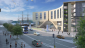
With the decline of traditional industry, the city has adopted a plan to regenerate and reinvent itself as a cultural centre.[13] In pursuit of this, a £1 billion master plan to regenerate and to reconnect the Waterfront to the city centre started in 2001 and is expected to be completed within a 30-year period, with the Dundee Victoria & Albert Museum opening 15 September 2018 at a cost of £80 million.[14][15]
In recent years, Dundee has had a rising international profile, with GQ Magazine naming Dundee the 'Coolest Little City In Britain' in 2015 and The Wall Street Journal ranking Dundee at number 5 on its 'Worldwide Hot Destinations' list for 2018.[16]
History[edit]
The name "Dundee" is made up of two parts: the common Celtic place-name element dun, meaning fort; and a second part that may derive from a Celtic element, cognate with the Gaelic dè, meaning 'fire'.[17]

While earlier evidence for human occupation is abundant,[18] Dundee's success and growth as a seaport town arguably came as a result of William the Lion's charter, granting Dundee to his younger brother, David (later Earl of Huntingdon) in the late 12th century.[19] The situation of the town and its promotion by Earl David as a trading centre led to a period of prosperity and growth.[20] The earldom was passed down to David's descendants, amongst whom was John Balliol. The town became a Royal Burgh on John's coronation as king in 1292.[21] The town and its castle were occupied by English forces for several years during the First War of Independence and recaptured by Robert the Bruce in early 1312.[22] The original Burghal charters were lost during the occupation and subsequently renewed by Bruce in 1327.[23]
The burgh suffered considerably during the conflict known as the Rough Wooing of 1543 to 1550, and was occupied by the English forces of Andrew Dudley from 1547. In 1548, unable to defend the town against an advancing Scottish force, Dudley ordered that the town be burnt to the ground.[24] In 1645, during the Wars of the Three Kingdoms, Dundee was again besieged, this time by the Royalist Marquess of Montrose.[25] The town was finally destroyed by Parliamentarian forces led by George Monck in 1651.[26] The town played a pivotal role in the establishment of the Jacobite cause when John Graham of Claverhouse, 1st Viscount Dundee raised the Stuart standard on the Dundee Law in 1689.[27] The town was held by the Jacobites in the 1715–16 rising, and on 6 January 1716 the Jacobite claimant to the throne, James VIII and III (the Old Pretender), made a public entry into the town. Many in Scotland, including many in Dundee, regarded him as the rightful king.[28]
A notable resident of Dundee was Adam Duncan, 1st Viscount Duncan of Camperdown, Baron of Lundie (1 July 1731 to 4 August 1804). He was born in Dundee on 1 July 1731, the son of Alexander Duncan of Lundie, Provost of Dundee. Adam was educated in Dundee and later joined the Royal Navy on board the sloop Trial. He rose to be admiral and in October 1797 defeated the Dutch fleet off Camperdown (north of Haarlem). This was seen as one of the most significant actions in naval history.[29]
The economy of mediaeval Dundee centred on the export of raw wool, with the production of finished textiles being a reaction to recession in the 15th century.[30] Two government Acts in the mid 18th century had a profound effect on Dundee's industrial success: the textile industry was revolutionised by the introduction of large four-storey mills, stimulated in part by the 1742 Bounty Act which provided a government-funded subsidy on Osnaburg linen produced for export.[31] Expansion of the whaling industry was triggered by the second Bounty Act, introduced in 1750 to increase Britain's maritime and naval skill base.[32] Dundee, and Scotland more generally, saw rapid population increase at end of the 18th and beginning of the 19th century, with the city's population increasing from 12,400 in 1751 to 30,500 in 1821.[33]
The phasing out of the linen export bounty between 1825 and 1832 stimulated demand for cheaper textiles, particularly for cheaper, tough fabrics.[34] The discovery that the dry fibres of jute could be lubricated with whale oil (of which Dundee had a surfeit, following the opening of its gasworks) to allow it to be processed in mechanised mills resulted in the Dundee mills rapidly converting from linen to jute, which sold at a quarter of the price of flax.[35] Interruption of Prussian flax imports during the Crimean War and of cotton during the American Civil War resulted in a period of inflated prosperity for Dundee and the jute industry dominated Dundee throughout the latter half of the 19th century.[36] Unprecedented immigration, notably of Irish workers, led to accelerated urban expansion, and at the height of the industry's success, Dundee supported 62 jute mills, employing some 50,000 workers.[37] Cox Brothers, who owned the massive Camperdown Works in Lochee, were one of the largest jute manufacturers in Europe and employed more than 5,000 workers.[38]
The rise of the textile industries brought with it an expansion of supporting industries, notably of the whaling, maritime and shipbuilding industries,[39] and extensive development of the waterfront area started in 1815 to cope with increased demand for port capacity.[40] At its height, 200 ships per year were built there, including Robert Falcon Scott's Antarctic research vessel, the RRS Discovery. This ship is now on display at Discovery Point in the city.[41] A significant whaling industry was also based in Dundee, largely existing to supply the jute mills with whale oil. Whaling ceased in 1912 and shipbuilding ceased in 1981.[42]

While the city's economy was dominated by the jute industry, it also became known for smaller industries. Most notable among these were James Keiller's and Sons, established in 1795, which pioneered commercial marmalade production,[43] and the publishing firm DC Thomson, which was founded in the city in 1905. Dundee was said to be built on the 'three Js': Jute, Jam and Journalism.
The town was also the location of one of the worst rail disasters in British history, the Tay Bridge disaster. The first Tay Rail Bridge was opened in 1878. It collapsed some 18 months later during a storm, as a passenger train passed over it, resulting in the loss of 75 lives.[44] The most destructive fire in the city's history came in 1906, reportedly sending "rivers of burning whisky" through the street.
The jute industry fell into decline in the early 20th century, partly due to reduced demand for jute products and partly due to an inability to compete with the emerging industry in Calcutta.[45] This gave rise to unemployment levels far in excess of the national average, peaking in the inter-war period,[46] but major recovery was seen in the post-war period, thanks to the arrival first of American light engineering companies like Timex and NCR, and subsequent expansion into microelectronics.[47]
A £1 billion master plan to regenerate Dundee Waterfront is expected to last for a 30-year period between 2001 and 2031.[48] The aims of the project are to reconnect the city centre to the waterfront; to improve facilities for walking, cyclists and buses; to replace the existing inner ring road with a pair of east/west tree-lined boulevards; and to provide a new civic square and a regenerated railway station and arrival space at the western edge. A new Victoria and Albert Museum is also being built, set for completion by 2018.[48]
Geography[edit]
.jpg)
Dundee sits on the north bank of the Firth of Tay on the eastern, North Sea Coast of Scotland. The city lies 36.1 miles (58 km) NNE of Edinburgh[64] and 360.6 miles (580 km) NNW of London.[64] The built-up area occupies a roughly rectangular shape 8.3 miles (13 km) long by 2.5 miles (4 km) wide, aligned in an east to west direction and occupies an area of 60 square kilometres (23 sq mi).[65][66] The town is bisected by a line of hills stretching from Balgay Hill (elevation of 143 m) in the west end of the city, through the Dundee Law (174 m) which occupies the centre of the built up area, to Gallow Hill (83 m), between Baxter Park and the Eastern Cemetery. North of this ridge lies a valley through which cuts the Dighty Water burn, the elevation falling to around 45 m. North of the Dighty valley lie the Sidlaw Hills, the most prominent hill being Craigowl Hill (455 m).[65]
The western and eastern boundaries of the city are marked by two burns that are tributaries of the River Tay. On the western-most boundary of the city, the Lochee burn meets the Fowlis burn, forming the Invergowrie burn, which meets the Tay at Invergowrie basin.[65] The Dighty Water enters Dundee from the village of Strathmartine and marks the boundaries of a number of northern districts of the city, joining the Tay between Barnhill and Monifieth.[65] The Scouring burn in the west end of the city and Dens Burn in the east, both of which played important roles in the industrial development of the city, have now been culverted over.
Urban environment[edit]

Very little of pre-Reformation Dundee remains, the destruction suffered in the War of the Rough Wooing being almost total, with only scattered, roofless shells remaining.[69] The area occupied by the medieval burgh of Dundee extends between East Port and West Port, which formerly held the gates to the walled city. The shoreline has been altered considerably since the early 19th century through development of the harbour area and land reclamation.[70] Several areas on the periphery of the burgh saw industrial development with the building of textile mills from the end of the 18th century. Their placement was dictated by the need for a water supply for the modern steam powered machinery, and areas around the Lochee Burn (Lochee), Scouring Burn (Blackness) and Dens Burn (Dens Road area) saw particular concentrations of mills.[71] The post war period saw expansion of industry to estates along the Kingsway.[72]
Working class housing spread rapidly and without control throughout the Victorian era, particularly in the Hawkhill, Blackness Road, Dens Road and Hilltown areas.[73] Despite the comparative wealth of Victorian Dundee as a whole, living standards for the working classes were very poor. A general lack of town planning coupled with the influx of labour during the expansion of the jute industry resulted in insanitary, squalid and cramped housing for much of the population.[74] While gradual improvements and slum clearance began in the late 19th century, the building of the groundbreaking Logie housing estate marked the beginning of Dundee's expansion through the building of planned housing estates, under the vision of city architect James Thomson, whose legacy also includes the housing estate of Craigiebank and the beginnings of an improved transport infrastructure by planning the Kingsway bypass.[75]
Modernisation of the city centre continued in the post-war period. The mediaeval Overgate was demolished in the early 1960s to make way for a shopping centre, followed by construction of the inner ring road and the Wellgate Shopping Centre.[76] The Tay Road Bridge, completed in 1966 had as its northern landfall the docklands of central Dundee, and the new associated road system resulted in the city centre being cut off from the river.[77] An acute shortage of housing in the late 1940s was addressed by a series of large housing estates built in the northern environs including the Fintry, Craigie, Charleston and Douglas areas in the 1950s and early 1960s.[78] These were followed by increasingly cost-effective and sometimes poorly planned housing in throughout the 1960s.[79] Much of this, in particular the high-rise blocks of flats at Lochee, Kirkton, Trottick, Whitfield, Ardler and Menzieshill, and the prefabricated Skarne housing blocks at Whitfield, have been demolished since the 1990s or are scheduled for future demolition.[80]
Climate[edit]

The climate, like the rest of lowland Scotland, is Oceanic (Köppen-Geiger classification Cfb).[81] Mean temperature and rainfall are typical for the east coast of Scotland, and with the city's sheltered estuarine position, mean daily maxima are slightly higher than coastal areas to the North, particularly in spring and summer.[82] The summers are still chilly when compared with similar latitudes in continental Europe, something compensated for by the mild winters, similar to the rest of the British Isles. The nearest official Met Office weather station is Mylnefield, Invergowrie which is about 4 miles (6.4 km) west of the City Centre.
A record high of 29.3 °C (84.7 °F) was recorded in July 2013.[83] The warmest month was July 2006,[84] with an average temperature of 17.4 °C (63.3 °F) (mean maximum 22.5 °C (72.5 °F), mean minimum 12.3 °C (54.1 °F)). In an 'average' year the warmest day should reach[85] 25.2 °C (77.4 °F), and in total just 1.63 days[86] should equal or exceed a temperature of 25.1 °C (77.2 °F) per year, illustrating the rarity of such warmth.
| Climate data for Mylnefield, elevation 31m, 1981–2010, extremes 1960–2010 | |||||||||||||
|---|---|---|---|---|---|---|---|---|---|---|---|---|---|
| Month | Jan | Feb | Mar | Apr | May | Jun | Jul | Aug | Sep | Oct | Nov | Dec | Year |
| Record high °C (°F) | 14.6 (58.3) |
15.2 (59.4) |
21.6 (70.9) |
22.9 (73.2) |
23.7 (74.7) |
27.8 (82) |
29.3 (84.7) |
28.7 (83.7) |
25.0 (77) |
22.8 (73) |
16.7 (62.1) |
14.5 (58.1) |
29.3 (84.7) |
| Average high °C (°F) | 6.4 (43.5) |
6.9 (44.4) |
9.1 (48.4) |
11.5 (52.7) |
14.4 (57.9) |
17.1 (62.8) |
19.3 (66.7) |
19.2 (66.6) |
16.5 (61.7) |
12.7 (54.9) |
9.1 (48.4) |
6.5 (43.7) |
12.4 (54.3) |
| Average low °C (°F) | 0.7 (33.3) |
1.0 (33.8) |
2.2 (36) |
3.9 (39) |
6.3 (43.3) |
9.1 (48.4) |
11.0 (51.8) |
10.9 (51.6) |
8.9 (48) |
6.1 (43) |
3.0 (37.4) |
0.7 (33.3) |
5.3 (41.5) |
| Record low °C (°F) | −17.1 (1.2) |
−11.2 (11.8) |
−10.0 (14) |
−4.4 (24.1) |
−2.3 (27.9) |
−0.7 (30.7) |
2.8 (37) |
1.7 (35.1) |
−0.6 (30.9) |
−3.4 (25.9) |
−10.4 (13.3) |
−12.7 (9.1) |
−17.1 (1.2) |
| Average precipitation mm (inches) | 71.1 (2.799) |
47.2 (1.858) |
53.3 (2.098) |
46.3 (1.823) |
48.1 (1.894) |
57.3 (2.256) |
56.9 (2.24) |
64.6 (2.543) |
65.7 (2.587) |
82.0 (3.228) |
68.4 (2.693) |
61.2 (2.409) |
722.0 (28.425) |
| Mean monthly sunshine hours | 53.6 | 77.3 | 116.2 | 145.9 | 191.2 | 166.4 | 174.3 | 166.3 | 126.0 | 95.9 | 69.8 | 43.1 | 1,426.3 |
| Source #1: KNMI/ Royal Netherlands Meteorological Institute[87] | |||||||||||||
| Source #2: Met Office[88] | |||||||||||||
Economy[edit]

The period following World War II was notable for the transformation of the city's economy. While jute still employed one-fifth of the working population, new industries were attracted and encouraged. NCR Corporation selected Dundee as the base of operations for the UK in late 1945,[96] primarily because of the lack of damage the city had sustained in the war, good transport links and high productivity from long hours of sunshine. Production started in the year before the official opening of the plant on 11 June 1947. A fortnight after the 10th anniversary of the plant the 250,000th cash register was produced.
By the 1960s, NCR had become the principal employer of the city producing cash registers, and later ATMs, at several of its Dundee plants. The firm developed magnetic-strip readers for cash registers and produced early computers.[97] Astral, a Dundee-based firm that manufactured and sold refrigerators and spin dryers was merged into Morphy Richards and rapidly expanded to employ over 1,000 people. The development in Dundee of a Michelin tyre-production facility helped to absorb the unemployment caused by the decline of the jute industry, particularly with the abolition of the jute control by the Board of Trade on 30 April 1969.[98]
Employment in Dundee changed dramatically during the 1980s with the loss of nearly 10,000 manufacturing jobs due to closure of the shipyards, cessation of carpet manufacturing and the disappearance of the jute trade. To combat growing unemployment and declining economic conditions, Dundee was declared an Enterprise Zone in January 1984. In 1983, the first Sinclair ZX Spectrum home computers were produced in Dundee by Timex. In the same year the company broke production records, despite a sit-in by workers protesting against job cuts and plans to demolish one of the factory buildings to make way for a supermarket. Timex closed its Dundee plant in 1993 following an acrimonious six-month industrial dispute.[99]
Modern day[edit]

Dundee is a regional employment and education centre, with around 325,000 people within 30 minutes' drive of the city centre and 860,000 people within one hour.[100] Many people from North East Fife, Angus and Perth and Kinross commute to the city.[101] As of 2015, there were 395 employers who employed 250 or more staff; over a five-year period (2011-2015) the number of registered enterprises in Dundee increased by 20.9% from 2,655 to 3,210.[101] The largest employers in the city are NHS Tayside, Dundee City Council, University of Dundee, Tayside Contracts, Tesco, D. C. Thomson & Co and BT.[101]
Other employers include limited and private companies such as NCR, Michelin, Alliance Trust, Aviva, Royal Bank of Scotland, Asda, Stagecoach Strathtay, Tokheim, Scottish Citylink, C J Lang & Son (SPAR Scotland), Joinery and Timber Creations, HBOS, Debenhams, Xplore Dundee, and W. L. Gore and Associates. Between 2009 and 2014 the hardest-hit sectors, in terms of jobs, were Information and Communication, Construction and Manufacturing which each lost around 500 full-time jobs. By contrast, the Professional, Scientific and Technical sector saw an upsurge in jobs in addition to the Business Administration and Support Service sector which increased by approximately 1,000 full-time and 300 part-time jobs in the same six-year period.[101] Gross median weekly earnings of full-time employees in Dundee in 2015 was £523.50; men received £563.40 and women £451.80.[101] Gross weekly pay for all employees in Dundee has increased from £325.00 in 2000 to £380.00 in 2015.[101]
The biomedical and biotechnology sectors, including start-up biomedical companies arising from university research, employ just under 1,000 people directly and nearly 2,000 indirectly. Information technology and Video game development have been important industries in the city for more than 20 years.[102] Rockstar North, developer of Lemmings and the Grand Theft Auto series was founded in Dundee as DMA Design by David Jones; an undergraduate of the Abertay University.[103] Other game development studios in Dundee include Denki, Ruffian Games, Dynamo Games, 4J Studios, Cohort Studios amongst others.

Dundee is also a key retail destination for North East Scotland and has been ranked 4th in Retail Rankings in Scotland.[104] The city centre offers a wide variety of retailers, department stores and independent/specialist stores. The Murraygate and High Street forms the main pedestrian area and is home to a number of main anchors such as Marks and Spencer, Accessorise and Zara.[104] The main pedestrian area also connects the two large shopping centres; the 420,000-square-foot (39,000-square-metre) Overgate Centre which is anchored by Debenhams, H&M, Next, Argos, and The Perfume Shop and the 310,000-square-foot (29,000-square-metre) Wellgate Centre by Home Bargains, B&M, Superdrug, Iceland, Holland & Barrett, Poundland, Savers, The Works, Hydro Electric, Bright house,[104] Other retail areas in the city include Gallagher Retail Park, Kingsway East Retail Park and Kingsway West Retail Park.[104]
Landmarks[edit]

The city and its landscape are dominated by The Law and the Firth of Tay. The Law, a large hill to the north of the City Centre was the site of an Iron Age Hill Fort, upon which the Law War Memorial, designed by Thomas Braddock, was erected in 1921 to commemorate the fallen of World War I.[105] The waterfront, much altered by reclamation in the 19th century, retains several of the docks that once were the hub of the jute and whaling industries, including the Camperdown and Victoria Docks.[106] The Victoria Dock is the home of the frigate HMS Unicorn and the North Carr Lightship, while Captain Scott's RRS Discovery occupies Craig Pier, from where the ferries to Fife once sailed.
The oldest building in the city is St Mary's Tower, which dates from the late 15th century.[107] This forms part of the City Churches, which consist of St Clement's Church, dating to 1787–8 and built by Samuel Bell, Old St Paul's and St David's Church, built in 1841–42 by William Burn, and St Mary's Church, rebuilt in 1843–44, also by Burn, following a fire.[108] Other significant churches in the city include the Gothic Revival Episcopal Cathedral of St Paul's, built by Sir George Gilbert Scott in 1853 on the former site of Dundee Castle in the High Street,[109] and the Roman Catholic Cathedral of St Andrew, built in 1835 by George Mathewson in Nethergate.[110]
As a result of the destruction suffered during the Rough Wooing, little of the mediaeval city (aside from St Mary's Tower) remains and the earliest surviving domestic structures date from the Early Modern Era. A notable example is the Wishart Arch (or East Port) in Cowgate. It is the last surviving portion of the city walls. Dating from prior to 1548, it owes its continued existence to its association with the Protestant martyr George Wishart, who is said to have preached to plague victims from the East Port in 1544.[111] Another is the building complex on the High Street known as Gardyne's Land, parts of which date from around 1560.[112] The Howff burial ground in the northern part of the City Centre also dates from this time; it was given to the city by Mary Queen of Scots in 1564, having previously served as the grounds of a Franciscan abbey.[113]

Several castles can be found in Dundee, mostly from the Early Modern Era. The earliest parts of Mains Castle in Caird Park were built by David Graham in 1562 on the site of a hunting lodge of 1460.[114] Dudhope Castle, originally the seat of the Scrymgeour family, dates to the late 16th century and was built on the site of a keep of 1460.[115] Claypotts Castle, a striking Z plan castle in West Ferry, was built by John Strachan and dates from 1569–1588.[116] In 1495 Broughty Castle was built and remained in use as a major defensive structure until 1932, playing a role in the Anglo-Scottish Wars and the Wars of the Three Kingdoms. The castle stands on a shallow tip projecting into the Firth, alongside two beaches, one of sand, the other of pebbles. The ruins of Powrie Castle, north of Fintry, date from the 16th-century castle north.[clarification needed][117]
North of the City Churches, at the end of Reform Street, lies the High School of Dundee, built in 1829–34 by George Angus in a Greek Revival style.[118] Another school building of note is Morgan Academy on Forfar Road, built in 1863, designed by John Dick Peddie in a Dutch Gothic style.[119]
Dundee's industrial history as a centre for textile production is apparent throughout the city. Numerous former jute mills remain standing and while some lay derelict, many have been converted for other uses. Of particular note are the Tay Works, built by the Gilroy Brothers c.1850–1865,[120] Camperdown Works in Lochee, which built and owned by Cox Brothers, one of Europe's largest jute manufacturing companies, and begun in 1849,[121][122] and Upper Dens Mill and Lower Dens Works, built by the Baxter Brothers in the mid-19th century.[123]

A more recent landmark is the 140-foot (43 m) Tower Building of the University of Dundee built between 1959 and 1961. At the time of its construction only the Old Steeple was taller in the city. The Tower was built to replace the original college buildings which stood on the site.[124][125] The building houses the university's main administration and includes galleries and the university's Archive, Records Management and Museum Services.[126]
Many 1960s landmark multi-storey housing buildings were demolished in the last decade.[when?] The former Tayside House block, nicknamed 'Faulty Towers' by many local people, was demolished in 2013 as part of the waterfront redevelopment program.[127] According to the architectural historian Charles McKean and his co-authors of Lost Dundee, the best views in the city were from Tayside House, because these were the only views from the building could not be seen.[128]
Transport[edit]

Dundee is served by the A90 road which connects the city to the M90 and Perth in the west, and Forfar and Aberdeen in the north. The part of the road that is in the city is a dual carriageway and forms the city's main bypass on its north side, known as the Kingsway. East of the A90's Forfar Road junction, the Kingsway East continues as the A972, and meets the A92 at the Scott Fyffe roundabout. Travelling east, the A92 connects the city to Arbroath and Montrose and to the south with Fife via the Tay Road Bridge.
The A930 links the city with coastal settlements to the east, including, Monifieth and Carnoustie. Progressing westward from where the A92 meets the Tay Road Bridge at the Riverside Roundabout, the A85 follows the southern boundary of the city along Riverside Drive and towards the A90 at the Swallow Roundabout. The A85 multiplexes with the A90 and diverges again at Perth.
Also meeting the A92 and A85 at the Riverside Roundabout is the A991 Inner Ring Road, which surrounds the perimeter of the city centre, returning to the A92 on the east side of the Tay Road Bridge. The A923 Dundee to Dunkeld road meets the A991 at the Dudhope Roundabout, and the A929 links the A991 to the A90 via Forfar Road.

Dundee has an extensive network of bus routes. The Seagate bus station is the city's main terminus for journeys out of town. Xplore Dundee operates most of the intra-city services, with other more rural services operated by Stagecoach Strathtay. The city's two railway stations are the main Dundee Station near the waterfront, which is currently undergoing reconstruction while remaining open, and the much smaller Broughty Ferry Station at the eastern end of the city.
There are other nearby stations at Invergowrie, Balmossie and Monifieth. Passenger services at Dundee are provided by Abellio ScotRail, CrossCountry, Caledonian Sleeper and Virgin Trains East Coast. No freight trains serve the city since the Freightliner terminal in Dundee was closed in the 1980s. There are also many intercity bus services offered by Megabus, Citylink and National Express.
Dundee Airport offers commercial flights to London Stansted Airport. Flights to Birmingham Airport and Belfast City were discontinued in December 2012.[129] The airport is capable of serving small aircraft and is located 3 kilometres (1.9 mi) west of the city centre, adjacent to the River Tay. The nearest major international airport is Edinburgh Airport, 59.2 miles (95.3 km) to the south.
The nearest international passenger seaport is Aberdeen.
The cargo port of Dundee is one of the largest economic generators in the city and is operated by Forth Ports. Seafarers arriving at the port are offered welfare and pastoral assistance by seafarers charity Apostleship of the Sea.
Parts of this text were copied from 
Conference Venue
 |
|
|
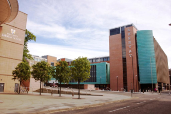
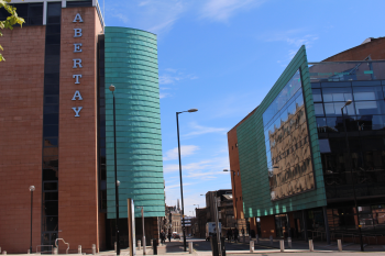
Getting to Dundee and Abertay University
By Plane
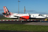

Dundee Airport, located in the heart of Scotland, is the most convenient fly-in destination for some 1000 square miles of central Scotland and operates 2 flights on week days to and from London Stansted (Loganair).
Taxis are available upon request from outside Dundee Airport and should take approximately ten minutes to arrive at the University.
Alternatively fly in through Edinburgh Airport and take a train from Edinburgh Waverley station to Dundee.
By Bus

We are just ten minutes' short walk from the bus station. Taxis are available in Trades Lane. (National Express Coaches, Megabus and Citylink).
By Rail - Dundee Station
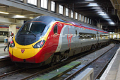
We are just ten minutes' short walk from the train station. Taxis are available outside its main entrance. Journey information is available from National Rail Enquiries. Tickets can be bought directly from East Coast and Virgin Rail.
By Car

Driving directions can also be generated from Google Maps.
There are a number of public car parks available around Abertay University.
Car Hire
There are many companies offering competitive rates to hire a car. Here are a few car hire companies to choose from:
- Avis (0870 60 60 100)
- Budget (0870 15 65 656)
- Hertz (0870 84 48 844)
- National Car Rental (0870 60 06 666)
- easyCar
On Foot

You can of course also walk to the University from any hotel, which should take you some 15 to 20 mins.
Campus Map
You can find detailed overview of how to get to Abertay University following this link.
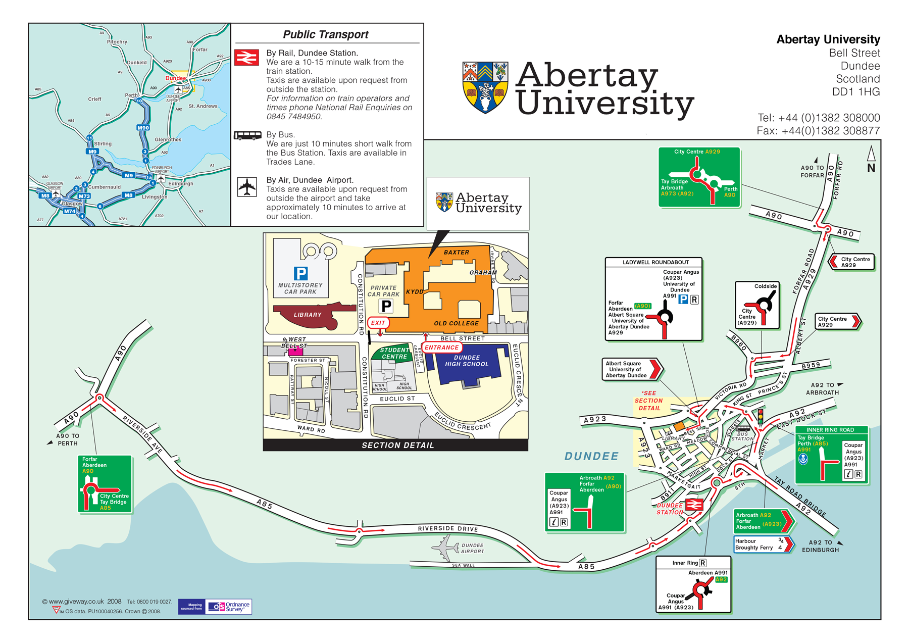
Click on the map above for a bigger view.